I Haven’t the Foggiest…

The Dalles was a nice enough area, but I try not to hang around too long at a place where a room at Day’s Inn is over $250 a night. I had picked the cheapest motel I could find, and it was still $90. Leaving the hotel, the radar looked clear, but it was very overcast and foggy. I headed up the Historic Columbia River Highway, which was wet, but beautiful. So much better than hopping on I84.

Once I got through Rowena, things got fun. The Rowena Loops, as I believe they’re called, were a great, if short, set of switchbacks and views of,well, fog. The skies couldn’t make up their mind whether they wanted to open the floodgates, shut them, or just let a few drops through here and there.

Riding up to Panorama Point State Park, I was hoping to get above the fog a bit to catch a glimpse of Mt Hood.

 photo P1030920_zpslvx83vds.jpg

I’m sure it’s in there somewhere. I decided to ride the loop down around Mt Hood to see if I could see it closer up. What I actually ended up seeing was miles and miles of heavy rain and fog with visibility slightly further than a cat can vomit. No, really, it was down to about 200 ft. I never saw Mt Hood, just the temperature dropping down to 41 and the rain pick up. I don’t mind riding in rain, but riding in rain in slow traffic is no favorite of mine. At one point, there were 10 of us vehicles stuck behind a Subaru Forester doing 15-20 mph. I’m from SC, where seing a Subaru is about as rare as seeing 13 small children riding a yak through the McDonalds drive through. I’ve noticed that there are two types of Subaru drivers, excluding the WRX/STi guys. There are the Subies covered in bumper stickers about coexisting, treehugging, etc, going 10 or more under the speed limit. Then there are the drivers putting all their faith in AWD and driving 15-20 MPH over the limit.

Once I got through Portland, the rain slowed, then stopped, as I headed for the coast. Not a whole lot to report between Portland and the coast, so here’s a few pic to finish out this installment.

 photo P1030926_zpsiad7fz75.jpg

 photo P1030923_zps7pnpkbyp.jpg

World’s Shortest River

 photo P1030970 2_zps6j5sakag.jpg

 photo P1030974 2_zps47ygliyt.jpg

 photo P1030976 2_zpsc12nc7vs.jpg

I rode down US 101 to Florence, where I camped. It was a beautiful night. I knew I was not on an East Coast beach as shown by the Warning- Elk signs along the beachfront.

Today’s Takeaway: I haven’t the foggiest.

Homeland Bioterrorism

Warmth. Dryness. Comfort. A crackling fire. A sizzling steak.

This is a list of things I did not have camping at Ukiah in Oregon. Having to set up my tent in the rain with not much tree cover, the inside was soaked. Thankfully, my air mattress is thick enough to keep me off of the wet tent floor. Morning came eventually, welcome for the daylight, unwelcome for rain still pummeling my immediate area. Once I juiced my tent and packed everything as quickly as I could, still in the rain, I waded my way back to the bike and set off once more, fording my way back to US 395. Turning south again, I passed the station at Dale, then continued onto Long Creek, there turning onto 402.

Things started changing up on 402, less “woodsy” and more sandy. This was a welcome change, because the forests of Oregon more or less looked like the forests of Idaho and Montana. In another welcome change, the sun was released from captivity and the rain and the roads dried up.

 photo P1030890 2_zpso4fxo3ae.jpg

I didn’t catch it on this picture, but there were about 20 cows crossing this bridge when I first came upon it.

Once I passed through Monument, the roads even became fun! Low brush meant it was easy to set up a corner, as I had a good sight line through it.

 photo P1030894 2_zpsaouyjzag.jpg

 photo P1030901 2_zps1oiudsdo.jpg

Fun was had all the way to Fossil. Fossil is a neat little town. I rolled down the road a bit to the John Day Fossil Beds. I was on my way up the trail to see if I could spy any fossils when I stumbled across this previously undiscovered fossil.

 photo IMAG0709_zpspfqtwoey.jpg

Buried just beneath the surface, it was a chance find, but it is obviously the well preserved trachea of a brontosaurus. Unfortunately, it’s not public land, so I couldn’t excavate it, strap it to the VFR and sell it to the Smithsonian for enough money to buy all of Oregon. What rotten luck.

While I was examining my find, a flash of red caught my eye, and that happened to be Scott? (I’m terrible with names) on his BMW R100. We talked a while and then went our separate ways.

 photo IMAG0704_zpsdqqt4ayu.jpg

 photo IMAG0707_zpszbnip1f8.jpg

Riding through Antelope was pretty neat, as I had been reading about the Rajneesh cult and how the town for a period of time in the 80’s was named Rajneeshpuram. Before my time, but hard to believe that happened. Read up on the Rajneesh cult history, if you haven’t. It’s rather fascinating.

I headed up into Shaniko, where I stopped at a small store to purchase a can of Coke, lean against the bike, and soak in my dusty, Western, almost ghost town surroundings. Refreshed, (no, I haven’t been bought off by Coca-Cola, although, Coke, if you’re reading this, I’m all for it!), I set up towards The Dalles, on an amazing road. What a brilliant road! Great pavement, curves, elevation, scenery. This stretch has it all!

 photo P1030904 2_zpskjo6hdc7.jpg

Once out of that stretch, things got flat, straight, and windy pretty quick. Pro tip: if there are hundreds of wind power plants, you’re in for a windy time.

In Bigg’s Junction, I was filling up when who should show up, but Scott(?) again on his BMW.\

 photo IMAG0710_zpseokdyvrp.jpg

I crossed the Columbia River over to Washington, then rode alongside the river.

 photo P1030911 2_zpscoqw64bw.jpg

 photo P1030915 2_zpszugjvacn.jpg

Simply beautiful.

The Dalles was the location of the largest bioterror attack in US history. The aforementioned Rajneesh cult was running for 2 of 3 county seats and decided to keep people in The Dalles (the largest population in Wasco County) from voting by poisining the salad bars in 10 restaurants with salmonella. 751 people were affected, none died, thankfully, but the attack had the opposite effect, in that the non cultish people turned out in droves to vote against the cult members.

Riding down the road, I noticed a freight train on the Oregon side seemed to be taunting me into a race. Not wanting to back down from a challenger that was only several thousand feet longer than me, I accepted. It was a close battle, I would get a nice straight stretch and pull ahead, the train had the shortest distance, no traffic to worry about, and more or less straight tracks. I, on the other hand, had the power of the V4. Crossing the bridge back to the Oregon side, things looked close, and I was parked at my motel walking into the office when the train came rolling by. The train, obviously enthused, said nothing but WOOOOOOO, but I knew he knew he was no match for the Honda, no matter how much he tried to mask his feelings.

Today’s Takeaway: Don’t eat the salmonella colored salad

Or I Gone…

The morning dawned like clockwork, no more like dish detergent. I am no morning person, but being awake and ready for a full day of riding is the nearest to bubbly to which I’ll come. The birds twittered cheerfully, or since I’m at a KOA, the bird sound clips twittered digitally over the hidden speakers in the trees. Another day of adventure beckoned.

 photo P1030814 2_zpsfwyl7lpl.jpg

Rolling back through Kamiah, I headed towards Lewiston. It really was a beautiful morning. Lewiston arrived with a minimum of fuss and talking with a couple of BMW riders, I decided to drop through Hell’s Canyon down to Enterprise. What a fantastic road! Climbing out of Washington, the road just cut back and forth on itself like a high score in Snake. Crossing into Oregon didn’t dull things, either. Just a great rider’s road with beautiful scenery to boot.

 photo P1030824 2_zps71h6i2gr.jpg

 photo P1030833 2_zpseflyfxaf.jpg

 photo P1030838 2_zpspg7gsv40.jpg

The one downside was that it went down to one lane and the delay was about 15 minutes of sitting in the hot sun. I always feel sorry for the flagman (person). That job would not work for this guy!. Boredom would kick in, I’d give the waiting dtivers a coin toss and hand them a lance for a little one lane jousting.

Arriving in Enterprise, OR, the clouds loomed ominously and rain was starting to come down to my level. What a great time to get lunch and wait out the rain. I chose Thai Enterprise. I had the Pineapple Fried Rice and it was delicious. More about this place in a later report.

Once fed, I exited to find the rain clouds now fleeing in terror back to the mountains. I headed down to Joseph to check out Lake Wallowa and met the couple on BMW’s I had spoken to in Lewiston. Enterprise and Joseph were both pretty cool cities, Joseph was a bit too touristy for me, but Enterprise had a very honest feel to it.

 photo P1030851 2_zpsjuqs76bu.jpg

Oregon agrees with me. I absolutely love all the older vehices still being driven, especially as work trucks. I met plumbers driving clean old Ford F100s, contractors pulling trailers with straight old Chevy C20s, numerous Chevy LUV’s (I have a special affinity for small pickups), and all sorts of 80’s cars still on the road. I’ve nothing against the 50’s and 60’s classics that everyone else seems to prefer, but a 57 Chevy and a 67 Camaro are starting to feel a bit cliched to me. I love 70s and 80s cars and trucks. A Chevette? Sure. AMC Gremlin? Saw one and was jealous. Chrysler Newport? Well, I don’t have my CDL.

Leaving Joseph, I headed over to La Grande, where I rode through Lehman Springs down into the Umatilla National Forest. My original plan had been to make it down to John Day to camp, but waiting out the rain burned too much daylight. At one point. I realized that I needed gas within 30 miles or so and the nearest gas station was 40 miles away, so I had to backtrack about 12 miles to one I had passed in Dale. When I got to the Dale station, it was closed, and had been since 5:00 PM. I sat outside the station for a while wondering what to do, when the owner of the station kindly walked down from his house, pumped me some gas (no self service in Oregon. Why? Not even the gas attendants know), and gave me a postcard and a short history of the gas station which had been open since 1921, I believe.

It was definitely too dark to make it to John Day now, so I had to backtrack another 15 miles to the Ukiah campground. It began to rain and cool off fast. It was quite the night, sleeping in a wet tent with the rain pouring down at a low temp of 33F.

Today’s Takeaway: Oregon is alright (when it’s warm)

Liquid Sunshine

Things looked pretty good, if a little chilly, leaving Trout Creek. I rode with a mission, a passion, if you will, called breakfast. The lady at the motel had recommended Minnie’s Cafe in Thompson Falls, so that’s where I headed. She had warned that the omelets were great, but were almost bigger than the plate. She didn’t lie.

 photo IMAG0699_zps8aek516q.jpg

What she didn’t say was that the plates were also larger than normal. I ain’t even mad. The omelet was great and the home fries even better.  A great start to a mediocre day.

I headed down 200 to Missoula (again) and then south to Lolo. Somewhere between Thompson Falls and Missoula, a steady rain began. The clouds hung low all day, although on the mountains, I don’t mind.

 photo P1030785 2_zpszso7qzin.jpg

There’s really not a whole lot to report on this stretch. When I got to Lolo, I obviously took the Lolo Pass into Idaho.
 photo P1030795 2_zps3cijo4wf.jpg

Wet, wet, wet. I’m sure this road can be a lot of fun when it’s dry, I mean I had some fun when it was really wet. I’m just really grateful for the exceptional wet grip of the PR3/PR4 tires.

 photo P1030798 2_zpsdbdxr6g2.jpg

It was beautiful, especially with the low clouds/fog.

 photo P1030806 2_zps8tkvbfwt.jpg

After the Pass, I started looking for a place to camp, but because of wildfire activity, all of the National Forest campgrounds were closed. I did something I promised myself I wouldn’t do on this trip. I camped at a KOA in Kamiah, ID. This one wasn’t bad as far as KOAs go, pretty quiet because they had just opened back up after having been evac’d for the fire.

I rode into Kamiah for some grub and ended up at a Mexican restaurant whose name I cannot remember. I had the Taquitos Fritos, which were decent, but hey, Idaho is pretty far removed from Mexico.

 photo IMAG0702_zpsm0jpyogh.jpg

Today’s Takeaway: I could just start wearing my rain suit by default.

Oat and Aboot in Canadia

Oat and Aboot in Canada

Waterton has a great campground. The shower was nice and warm on a chilly morning. Actually, it wasn’t too chilly, it was low 50’s. I’m sure that number is lower in Celsius, but I can’t be bothered right now to convert it. Actually, when I was in Canada, I had a ton of fun. I absolutely love doing math in my head, and having to do all the metric conversions on the fly was a blast, along with figuring out what prices came to in “real money.” I gave up at gas stations, though.

Packing up my tent, I was somehow hungry again, so I headed back to Wieners of Waterton for a breakfast dog. The dog consisted of sausage, egg, cheese, onions, peppers, salsa, and a bit of sriracha. Great stuff! Heading out of Waterton, the plan was Banff National Park. I decided to come in from the west side, which meant going over Crowsnest Pass.

When I stopped for gas in Crowsnest Pass, the guy behind the counter advised against going to Banff. I knew it was cold, but I didn’t realize that it was already down to 41 degrees and raining in Crowsnest Pass and Banff was several hours north yet. I pulled up the forecast and I saw something I didn’t exactly relish, snow. That sealed it, one of the things I had been looking forward to the most, Banff, was off. Instead of going back through Waterton, I pushed on into the storm over Crowsnest Pass. It was cold. It was rainy. I think I’ve suppressed the rest of the memories from that stretch.

 photo P1030736 2_zpsynbm5env.jpg

This tree has marked the beginning of the Pass for years, but it died in 1971. Wind got the best of it later, so now its anchored with metal rods.

 photo P1030742 2_zpsywlcxjhj.jpg

In what’s left of the town of Frank, there was a monument to the buried town. In the middle of the night in 1903, a chunk of limestone over a kilometer wide, 425 meters long and over 100 meters deep broke loose off of the mountain and cascaded onto the sleeping mining town of Frank, burying most of it and sending 70 people to their deaths. Ironically, those working the night shift in the mines were able to tunnel out. The rocks have been unmoved since then, and in a sign of Canadian respect, I was very glad to see absolutely no graffiti on the rocks.

I stopped in Sparwood, BC for lunch. Because I just needed to eat and run and hopefully have WiFi, I chose the local A&W. The Canadians have a fascination with maple flavoring, with which I am totally on board. I had the Maple Chipotle Bacon burger which was really good, and guess what? They offered sweet potato fries with chipotle mayo sauce. I’m digging it.

 photo IMAG0692_zpswzt66v9m.jpg

Sparwood advertised having the “World’s Largest Truck.” I don’t know about the World’s Largest, but it was big! What blew my mind was the engine took 287 gallons of oil.

Dropping down through Fernie back into these United States, I passed through the border once more. The American side was quite a bit more thorough in their interrogation. Nothing like making you feel irrationally guilty for having done nothing wrong. 

Once in the US of A again, I was riding down 37, when I decided to be a little adventurous and cross Lake Koocanusa (terribly unoriginal name, by the way) and ride the length of it on  National Forest Service Road 228. This was awesome. I had the road to myself for the best part of 42 miles.

 photo P1030747 3_zps34ihmqqj.jpg

I passed one or two Forestry trucks in that time, but other than that, the road was my personal playground. It was on this road that I saw the most American scene that I’ve personally witnessed.

I’m on a extended motorcycle trip across America, camping along the way, riding a forest service road above a beautiful lake. Sheer rock wall to my right, freight train chugging along on the other side of the lake, when a bald eagle swooped down into the lake and had takeout sushi. Amazing stuff.

Moments like this have been branded “Kodak moments” for a little older age or GoPro moments for today, but I argue that it’s a memory moment. I’m glad that I wasn’t distracted by a camera, trying to capture the scene, but instead was able to view it unimpeded by a need to capture and share it with others. I’m the only one who saw that scene, and while I can try to describe it to you, there’s a certain romantic notion in the fact that it will live in my memory only. I feel that so much of today’s world is being captured to share with others that we miss out on the moments ourselves or that we allow what we think would be a great shareable media (picture, video, Vine, etc) to force our hand into doing something that we think would be popular rather than just enjoying and living in that moment. In the end, I’d rather have a vivid memory of a scene than a hasty photograph. Despite that, I feel that ride reports are a vital part of travel. I find it’s a great time for reflection on the past days and can help prolong memories.

I had to cut a U turn when I saw a swinging bridge. I went for a short quick hike back to Kootenai Falls and the swinging bridge.

 photo P1030761 2_zpsxn5zpmjy.jpg

 photo P1030776 2_zps8m5rjsuu.jpg

Just incredibly beautiful. I rode on until it got dark and I realized I wouldn’t make it to the campground, so I grabbed a room in Trout Creek, Montana.

Today’s Takeaway: Live for the moment, not to capture it.

Montana Redeemed

Montana Redeemed

So far, Montana hadn’t made the greatest of impressions, but expectations were high, because today I’d tour Glacier National Park. Glacier is one of the main reasons I wanted to make this trip, so I was really looking forward to it, and boy, it didn’t let me down!

I packed up camp back on Flathead Lake, retrieved my food from the bear lockers (first time using those), and set out heading north. It was a pretty uneventful ride to Glacier. I stopped just outside the park for a drink and a snack. The gas station had a wide assortment of chips in various flavors I’d never heard of before, including Cheddar and Beer, Thai flavoring, and Bacon and Maple. I tried the Bacon and Maple chips and they were actually pretty decent!

I headed into the park from the west side on advice from the guys at the diner in Wyoming. They said the best views are had from riding from west to east, and I believe I’d have to agree with them. I was a bit underwhelmed at first, wondering when the climb started. The river was beautiful and all, but following umpteen tour buses needed more than a river to keep my attention. When the climb started, things got dramatic quick. The air was crisp, the wildfire smoke mostly gone. Other than the sometimes monotone rambling drifting out of the open top tour buses, I was left with the sounds of Nature; the wind, the birds, the river, and of course that V4 melody.

Until I rode through Glacier, I dismissed the phrase “jaw-dropping” as a figure of speech. What would compel someone’s jaw to hang slack, I asked? It made no sense. Until it did. I don’t really know how to describe it, other than coming around a corner and feeling like you’ve just been gut punched with beauty. Riding on, slack-jawed, every corner offered a new vista, each one a unique view of the majesty that lies within the park.

 photo P1030662 2_zps2gkwaymo.jpg

 photo P1030688 2_zpsv52hqcay.jpg

 photo P1030700 2_zpsc4cxsdgu.jpg

 photo P1030707 3_zpsq2wlri9f.jpg

Leaving the park (regretfully), I headed north for Alberta. I took Chief Mountain Hwy and the difference could not have been more stark between America and Canada’s sides. On America’s side, crap. Crap everywhere. Free range cattle lounging on the road, defecating, and sometimes bleeding to death judging by some stains in the road. Canada side? Spotless. Numerous scenic pulloffs with restrooms and tidy parking.

 photo P1030720 3_zps6hahjg7z.jpg

 photo P1030724 3_zpsenwpn4oh.jpg

This was my first time in Canada, so getting through the Border took a little longer, but very straightfoward. It wasn’t long and I was at Waterton National Park. Inside the park is Waterton Village a small town of approximately 100 year round residents. There were several restaurants, shops, and so forth. I set up my campsite, then went into town for a little food.

 photo IMAG0682_zpsy0xnz7wm.jpg

 photo IMAG0683_zpsmny5lmsc.jpg

I chose Wieners of Waterton. Best hot dog ever. It had everything and the kitchen sink on it, and then they offered to add crumbled chips on top, so why not? Not to mention the amazing sweet potato fries with chipotle mayo sauce. The workers were very friendly and welcoming. The fact that the US dollar is a little more powerful these days helped too. Canada gets my vote!

 photo IMAG0686_zpslyv6xjb6.jpg

That evening, right before I bedded down, two bikes rolled into camp. I went to talk to the riders and it turns out they were from California heading for Banff NP like I was. They were riding a brand new Indian Scout and an older but good looking Honda CB900C.

Today’s Takeaway: Pictures might be worth a thousand words, but being there, being silent, and soaking in your surroundings is worth unbelievably much more.

In Which I Spend Much Money

In Which I Spend Much Money

Upon regaining consciousness from a (not long enough) night’s sleep, I spent most of the morning calling all the motorcycle shops and dealers in the Missoula area looking for a rear tire. The same story everywhere, “That’s not a Harley size, we don’t have anything like that.” Even the Honda dealer would have had to order the tire at a ridiculous price and it would have meant staying in Missoula for several more days which was NOT on the top, middle, or bottom of my list. On the bright side, I found my keys. They were wrapped up in a towel and didn’t come to light until I shook everything out.I was growing a strong dislike for Missoula, and in fact, only one thing keeps it from being right up there with New Jersey on the “actively avoid” list. That one thing being the breakfast I had at a small local diner.

 photo IMAG0660_zpslbhbaqt9.jpg

I had the Ham Scramble and it was pretty good. Looking around the diner, I noticed that the diner sponsored a local high school trap shooting team. My kinda place. I finally found a place that had a tire and for a reasonable price, but I had to ride 50 miles south to Hamilton, MT to get it. Thankfully, there was a laundromat there and I dropped off my clothes prior to tearing down the bike at the dealer. Strangely enough, it ended up being a Yamaha dealer, Al’s Cycles that had the correct size and the tire I wanted (Michelin Pilot Road 4) and were able to balance a single sided swingarm wheel.

 photo IMAG0663_zps4cft8xy4.jpg

Finally, at 3:30 PM, the tire was on, I picked up my now clean laundry and things were looking up. I had to ride right through Missoula on the way to my campsite, ugh. Riding up to Polson, MT was pretty uneventful.

 photo P1030618 2_zpsfyhkhnf3.jpg

Nice view of Flathead Lake

I’ve been using freecampsites.net for locating free or cheap camp sites. It’s worked great so far. Until today. I rode around Lake Flathead to Finley Point, a long peninsula out into the lake. Riding back in on the (terrible) pavement, I came across several deer. They were completely fearless, I even had to wait for one to mosy it’s way across the road with me honking my (feeble) horn to spur it on. When I rounded one corner, there was a fawn that was either really spooked or stupid as a bag of rocks. He was facing a high fence, backing up several feet and then charging the fence head first and every time, he only made it up to his neck then got flung back by the fence. I stopped and shut the bike off to make sure that I wasn’t spooking him into doing it, but he persisted. I made a wide berth around him and continued down the road looking for this mythical free campground. After a complete loop of the land, I came across Finley Point State Park, but they wanted to charge $28 for one tent site. Ridiculous!

The site had said there was a free campground. I rode around looking for it for another 15 minutes or so and finally stopped to ask a local where it was. Apparently, it had been taken over by the state park. I was faced with the choice of riding back to Polson and paying $80 for a motel room, riding 80 plus miles to the nearest free campground at dusk already, or suck it up and pay $28 for camping in a 10 acre state park. I chose to stay at the state park, but they couldn’t make me be happy about it. I can see spending that kind of money to camp at a popular or majestic park like Glacier, but a 10 acre state park? Crazy. At least I saw a decent sunset over Lake Flathead.

 photo P1030625 3_zpsnznrdnk7.jpg

Today’s Takeaway: Sometimes, a lack of options leads to a lack of wallet thickness, but you don’t have to like it.

Mon(ton’a) Problems

Mon(ton’a) Problems

It all started so innocent, so bright, such an unassuming day. The wind rustled through the trees, Yellowstone River a stone’s throw away (if you can throw 900 ft) was gurgling contentedly and fellow campers dropping by to shoot the breeze. My mood had lifted from the windy, tiring day before and things were looking good. I warmed up some breakfast (Campbell’s chicken and dumplings if you must know) and went down to the river just to sit, think, and take a few photos.

 photo P1030614 2_zpsjjm8pmum.jpg

Leaving Columbus, I90 was pretty much the only thing on the schedule that day. My rear tire was getting pretty worn down, so I figured Missoula was my best option for finding a replacement for said tire. Around the time I hit Bozeman, I too was hit. Hit with the realization that I didn’t remember pulling the keys out of the side case when I left Columbus. I searched everything on the bike and myself. No dice. Which was a bummer, because now I can’t play Yahtzee. Also, I found no keys.

Luckily I had one spare key for my clothing case, so the only case I couldn’t get into was the one holding all my bedding stuff; air mattress, pillow, sleeping bag, stack of reading material and so on. In other words, I needed in there, but as I was getting a motel in Missoula, it wasn’t critically urgent. More about that motel later.

I stopped for lunch in Bozeman at Clark’s Fork. Pretty neat place, its a cafe decorated with excerpts from Lewis and Clark’s journals taken out of context to advertise their menu items. Novel idea. I had the Southwest breakfast burrito (yes, breakfast for lunch. I love breakfast. I will not apologize for that. If I ever decide to run for President, my platform will be on breakfast menus being served all day long).
The burrito was good, the freshly fried chips were even better.

 photo IMAG0652_zpswyibrei7.jpg

Grinding down I90 once again, things were going well. Well, until Butte, that is. After riding through Butte, the wind got crazy. If you’ve never ridden in high winds, especially crosswinds, allow me to give you an example. Say you’re sitting in an office chair. Now imagine a midget standing behind you, or a regular height person crouching if you’d rather. Now whichever person you chose grabs your head and shakes it up and down, side to side with varying force and intensity for 3 hours. Got that? Good, now imagine that your office chair suddenly gets jerked 4 feet to the side randomly. That is how high winds do.

There were several times I was blown a lane over, despite steering into the wind. You have to stay alert, looking for trees bent over, etc to point out the really windy spots so that you can take early action. After about 3 hours of this, I was sick and tired of the wind. What could make things better? How about some rain? How about the bike sputters, coughs and shuts off? How about all of the above?

Out of gas. At 180 miles, I usually have between .75 to 1 gal of gas remaining. Fighting the winds must really have sucked some fuel down. The fuel gauge that had been showing 3 bars jumped straight to empty.

I called my insurance company for roadside assistance, and I figured it’d take a while, being Montana. Boy, was I right. The initial text said an ETA of 75 minutes. The closest available truck was in Ronan, while I was 11 miles east of Missoula. I was 11 miles away. 11 miles away from my warm, dry motel, that long hot shower I longed for, and the laundry service that I also direly needed.

 photo IMAG0657_zpsne2yjjbm.jpg

 photo IMAG0659_zps80lzcqyq.jpg

It ended up being over 2 hours of sitting in the rain, 50 degree temps and high winds before help arrived. And then came the cops. Apparently as I sat propped up against the mile marker sign, trying to stay dry and eating beef jerky, someone phoned 911 and said I was slumped over my bike, so a Missoula County Sheriff came out to check on me. When he realized that I was fine and that the truck had just shown up to bring me fuel, we talked for a while, he wished me luck on my trip and left. One of the flyest cops I’ve ever met.

It turns out that the service truck had been in Polson when he got dispatched to me. That explained the longer wait, but I was glad to be finally going again, thanking myself for paying that $5 a year for roadside coverage. When I pulled into my motel, I had two things on my mind. Bed and a hot shower. But first, I needed to get my laundry going. I had selected this particular establishment based on their advertisal of having a 24hr coin op laundry. Well, in keeping with the day, it was out of order despite the LED billboard out front loudly boasting it’s existence. I rode around town trying to find a 24 hour laundromat, but all the laundromats closed at 9PM. Ridiculous. I ate McDonalds out of spite and went to bed in my nonsmoking room that reeked of smoke. So goes it.

Today’s Takeaway: That light at the end of the tunnel? It’s a train.

Wyomin(gore)

Wyomin(gore)

This is going to be a two for one report, from Spearfish, SD to Powell, WY and from Powell to Columbus, MT.

After leaving Bell’s Motor Inn, I made tracks for Devil’s Tower in Wyoming. The first thing I noticed is how much wildfire smoke hung in the air, hiding the mountains from sight. From my rough calculations, I would say that visibility was right at a mile and a half, basically really bad out West. Once I got into the mountains, the smoke persisted and visibility worsened. To help you understand this, picture a mountain. Now picture that mountain half hidden in smoke. Did that clear things up? No? Well, neither did the smoke.
 photo P1030485_zpsp5c8kz6m.jpg
Devil’s Tower was pretty neat, but it really was one of those things that can be admired from the parking lot, so that’s what I did. I had a conversation with a guy parked next to me that was waiting on family to come back from a hike. This seemed to spark a chain of events down the road, but more on that later.

I stopped to watch the prairie dogs for a while, and when I was about to leave, the vehicle in front of me ran over one of the prairie dogs. They didn’t notice, but when they walked back to their car, that dog must have went and hidden underneath. As its spleen was receiving a little more sunlight than it was used to, it lay gasping for breath and dying shortly. It kind of made me think that sometimes the actions we take to avoid something we fear can become more detrimental to us than just facing the fear itself.

I stopped for lunch about an hour down the road from Devil’s Tower at Donna’s Diner. As I was eating, Donna (I presume) and another customer were talking. The other woman mentioned that her brother was in trouble because he mowed down 18 cows with his semi because he wasn’t paying attention. I didn’t put too much stock into it, chalking it up to idle gossip and small town exaggeration, when who through the front door should walk, but the guy I had been talking to at Devil’s Tower. Small world.

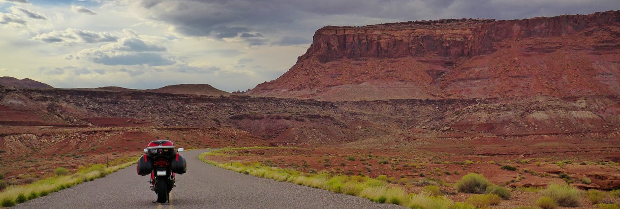
Back on the road, I-90, I was almost to Gillette when I passed two very distinctive vehicles; a black Chevy conversion van with green airbrushing and a Toyota Highlander pulling a neat little homemade travel trailer.

 photo P1030501_zps9r8ubgwh.jpg

Oh, the wonders of Interstate travel

From I90, I peeled off onto 14W and then onto 14A through the Bighorn National Forest. A simply wonderful ride. It cooled down from 93F to about 62F at the top. It was quite refreshing.

 photo P1030525_zpsgxu5dsov.jpg

Vanessa wanted to see, too…

All sorts of wildlife were out, unfortunately all of them were insects. What’s the last thing to go through a bug’s mind when it hits a VFR? It’s butt.

 photo IMAG0640_zps4ewxqm7p.jpg

My parents were both teachers, so I developed the habit of picking out typos in signs at 70 MPH.

 photo P1030522_zpscnrb0lhe.jpg

Exhibit 1: Keep it classy, Wyoming

Coming down the mountain was equally thrilling.

 photo P1030537_zpsgcn7kgo2.jpg

I arrived in Powell and set up my tent, and then in a risky maneuver, left it there and went into Cody to see what was up. Again, it seemed a bit too touristy and I headed back to Powell. What’s crazy is that I saw those two exact vehicles that I had noticed earlier in Cody. I wouldn’t have even seen the one, but I happened to go by right as they were pulling out of a lodge. A little coincidental?

 photo IMAG0637_zpsbqhz1ak3.jpg

The city of Powell, WY has a very cool park arrangement. It is a combination rest stop, RV dumping station, city park and pool, has a designated free tent camping area, and to top it all off, WiFi. The tent camping area was spotless and had a picnic table and grill.

Second Day.

I packed up camp and headed for some breakfast. I had spotted the Skyline Cafe the night before and it looked just down my alley. I walk inside, typical small town diner. I perused the menu, noting all the typical breakfast fare, when something out of the ordinary for this South Carolinian caught my eye. Under the Omelet section, they had an Apple and Sausage omelet smothered with cheddar cheese. I waffled a bit, not sure if that was what I was looking for, but then decided, I’m on a trip, I’ll take the risk. When it came out, I bit into it hesistantly, but it was not bad at all. I would have used a bit more cinnamon in the apples and maybe a different kind of sausage, but overall, not bad at all.

 photo IMAG0638_zpscg9rh5ig.jpg

What I love the most about small town diners is just sitting back and people watching, both the tourists and the regulars. Partway through my unusually fruit laden omelet, a man walked that could have summed up small town America. Blue jeans, boots, button down shirt, trucker hat. He was greeted with a chorus of “Hey, Glen” from the wait staff and sat down at his usual spot as they fixed him the regular. He and another local started talking and my ears perked up when I heard that the topic involved cattle being mowed down by a semi. The other guy talking to Glen was saying that he was second on the scene of a semi mowing down a whole herd of cows and hitting the car of one of those “terrist” girls. The woman at Donna’s Diner, hundreds of miles away was right, and here I was listening to these locals talk about the incident when me, some random guy from out of many states, had just happened to meet the guilty party’s sister the day before. Crazy stuff. It turned out to be 16 cattle dead at the time of writing, and they had to bring the plowtrucks out to scrape off the cow guts and feces enough to open one lane. I’m including the article here:

 photo IMAG0639_zps7tum4nio.jpg

Glen and I talked a while, then I headed off towards Cody where I hit up a Tractor Supply and found some bolts and washers to temporarily replace the ones that were taken by the South Dakota gravel road tax. Leaving Cody, I headed up Chief Joseph Highway. Man, what an incredible ride up! At the top, I met two gentlemen travelling from Georgia. We left within a day of eachother and have some similar destinations, so who knows, we might meet again. They were riding an unusual coupling of a Victory bagger and a Kawi C14.

 photo P1030583 2_zpsfoljmecw.jpg

Coming down Chief Joseph was another story. Soooo much loose gravel. I’ve never seen a road that bad. I was descending at under 20 MPH and still had quite a few times when the front wheel slipped out quite a bit more than I would have preferred it to. Thankfully, halfway down, it cleared up and things were all downhill (which is good) from there.

Cuttting right onto 212, or Beartooth Highway, I gained some serious elevation in a short amount of time, topping out at 10,974 ft and a temperature drop from 91F to 51F. The wind was pretty crazy at the top, and I parked and went climbing on some rock piles for a good picture. 15 minutes of making my way through and up the rocks, I pulled out my camera only to see the low battery light come on, and it immediately going comatose. Luckily, I had my phone on me, but the picture quality just isn’t justice.

 photo IMAG0646_zpswzeafl8u.jpg

The smoke from the day before had pretty much been driven away with northerly winds and I could see for miles. There’s still some ice up there in the mountains, but I didn’t plan on getting closer to ice than I absolutely had to. I rode down in a hurry since it was beginning to rain and with the high winds, the rain felt much worse. One really cool thing is that I got behind a camper from Switzerland. It was like a Toyota Prado, a manual diesel Land Cruiser sort of deal with a snorkel, just like the ones in Nicaragua. Color me jealous.

After a quick bite to eat in Red Lodge. I headed north, but didn’t make it very far before the rain hit. With the rain, came the wind. I was having to hold my bike from coming off the kickstand, the wind was so heavy. When I finally got all suited up, the rain quit a quarter mile down the road, as rain is a fickle thing and only takes pleasure in making riders suffer. Or something like that.

I’m now staying at Itch-kep-pe Park in Columbus, Montana. Heading for Glacier tomorrow.

Todays Takeaway: You really should look out for cows.